好消息:微软行星云计算更新发布了Planet Science Update

简介: 好消息:微软行星云计算更新发布了Planet Science Update

主要内容就是我邮件收到来自他们的信息,具体内容已经翻译成中文了。

Hello Researchers,

新年快乐! 谈到Planet的科学社区,我们今年有很多令人兴奋的事情。我们也很想看看你们都想出了什么新的研究应用。你可以在我们的2020-2021年科学应用手册中回顾去年的一些大型研究出版物。

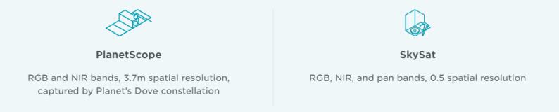
这个月,我们将举办一个关于我们新的PSScene资产和如何访问我们的8波段SuperDove数据的培训课程。你将能够通过我们任何一个有PlanetScope访问权的科学项目访问这些数据集,包括教育与研究(E&R)和NASA商业小卫星数据采集项目。

请记住,世界上任何有学位授予权的机构都有资格申请我们的教育和研究项目 此外,任何由联邦民用机构(即NASA、USGS、NOAA、USDA等)资助的研究人员都有资格通过NASA CSDA申请数据访问。如果你已经注册了,那么一定要把这些项目的信息传播给你的任何可能有资格和感兴趣的同事。

此外,如果你有论文或会议报告要使用Planet数据,并希望我们在《科学更新》或我们的博客和社交媒体上进行宣传,请将其发送给我们

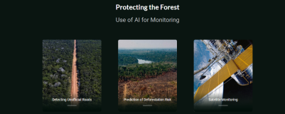
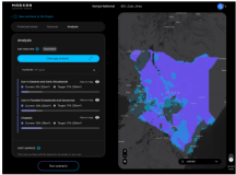
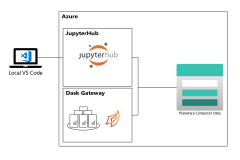
下面是邮件附带的一些其他方面的内容,看看有没有你感兴趣的,如果有的话,可以通过文件中附带的链接来完成注册


Understanding The Downstream Impacts Of On-Farm Reservoirs

On-farm reservoirs play a critical role in crop irrigation. They store water during the wet season for subsequent use for crop irrigation during the dry season. In the U.S. alone, there are an estimated 2.6 million such reservoirs. However, storing this water has poorly understood impacts on downstream hydrology and ecosystems. The amount of water stored also varies from year to year based on the precipitation rates of the wet seasons. A new study led by Vinicius Perin of North Carolina State University, partially conducted while Perin was an intern in Planet’s Professional Services team, utilizes Planet data in combination with European Space Agency Sentinel-1 radar and Sentinel-2 optical data. It studies the variations in these reservoirs at sub-weekly timescales across the seasons. Many of these reservoirs are smaller than 50 ha in surface area, so high resolution imagery is required to accurately determine their extents. Analyzing over 700 separate reservoirs, Perin et al. created a method involving Kalman filters to monitor reservoir surface area change over time. “[T]he approach presented in this study [has] the potential to enhance water conservation plans by allowing better assessment and management” of on-farm reservoirs, the authors note in their paper. “[T]his information can be used for water irrigation management recommendations aiming to increase water use efficiency.”


The full study can be found in Remote Sensing of Environment.

READ MORE

SkySat view of the Hunga-Tonga Hunga-Ha'apai volcano on July 14, 2021.

FEATURED SCIENCEExpanding Islands in the South Pacific

In early 2015, an underwater volcano in the South Pacific explosively erupted, forming a new island within the Polynesian nation of Tonga. Scientists initially thought that the island would vanish within a matter of months, which is often the case for small volcanic islands due to the erosive power of ocean waves. But seven years later, the island not only still stands—it has grown dramatically. Scientists at NASA’s Goddard Space Flight Center are keeping a close eye on the island changing with Planet and other satellite datasets.

READ MORE


ANNOUNCEMENTSUpcoming Webinar: Predicting, Monitoring, and Analyzing Wildfires With Planet Data

Join us on Wednesday, February 2nd to learn how Planet data can help determine solutions for wildfires during all stages of fire emergency management response, including pre-fire assessment, active fire monitoring, and post-fire recovery. These fire management tools can be integrated into broader applications, including other data sources, to help form clear insights for direct fire response efforts.

In this free webinar, you’ll learn how to utilize Planet imagery for:

  • Monitoring dynamic pre-fire risk conditions and environmental baselines
  • Identifying potential area spread and locations of standing water while responding to active fires
  • Classifying post-fire areas of recovery, burn scars (including intensity and severity), vegetation health, as well as determining potential landslide risk criteria
  • Data visualization outputs using a variety of PlanetScope imagery in different supported integrations, such as Google Earth Engine and ESRI ArcGIS
REGISTER HERE

ANNOUNCEMENTSNext Planet Researcher Training Sessions: New PSScene Asset Types and Accessing 8-Band SuperDove Data; API Toolchains

Searching for and downloading Planet data is about to get easier with our PSScene assets. Product Manager for Imagery Production Mariana Curdoglo, will discuss the technical details of PSScene assets, including accessing our 8-band SuperDove data on Friday, January 28th at 9AM PT/12PM ET.


On Friday, February 11th at 9AM PT/12PM ET, we will be hosting a webinar where you will learn about Planet API tools and toolchains, and how you can leverage these to reduce your time and effort in preprocessing from Solutions Architect Dr. Samapriya Roy. We will work with how to do band math, composite, reproject, and more.


Register for free at the links below.

Missed one of our previous training sessions? Don’t fret—they’re all available in one YouTube playlist for your convenience!

REGISTER FOR PSSCENES
REGISTER FOR TOOLCHAINS

CONFERENCE

Upcoming Conferences

Call for Abstracts: Frontiers in Hydrology

ABSTRACT DEADLINE: JANUARY 26, 2022

The American Geophysical Union and Consortium of Universities for the Advancement of Hydrologic Science, Inc., are accepting abstracts for a new meeting for the hydrology community, the Frontiers in Hydrology Meeting, to be held June 19–24 2022, in San Juan, Puerto Rico. The greater hydrology community requested and created this inaugural, biennial Frontiers in Hydrology Meeting to:

  • Communicate science and its integration in other disciplines
  • Formulate, implement and test innovative approaches to convene the water community in a format that elevates discussion rather than presentations
  • Create new multidisciplinary collaborations
LEARN MORE

53rd Lunar and Planetary Science Conference (LPSC)MARCH 7–11, 2022

The 53rd Lunar and Planetary Science Conference (LPSC) will be held as a hybrid conference on March 7th–11th, 2022. LPSC is recognized as the world’s premier planetary science conference, bringing together international specialists in petrology, geochemistry, geophysics, geology, astronomy, and astrobiology to present the latest results of research in planetary science. With in-person and global virtual participation, attendees will have the opportunity to share their research and network with colleagues. Mark your calendars and join us for the 53rd LPSC!

REGISTER HERE


相关文章
|
存储 传感器 编解码
微软行星云计算planet platform中的高分辨率影像通过API接入Google Earth Engine(GEE)
332 0
微软行星云计算planet platform中的高分辨率影像通过API接入Google Earth Engine(GEE)
|
存储 编解码 算法
微软行星云计算Planetary Computer——重投影和重采样(方法1)
363 0
微软行星云计算Planetary Computer——重投影和重采样(方法1)
|
存储 JavaScript 前端开发
微软行星云计算Planetary Computer——从 STAC API 读取数据
537 0
微软行星云计算Planetary Computer——从 STAC API 读取数据
|
编解码 数据可视化 API
微软行星云计算Planetary Computer——Sentinel-2 Level-2A数据去云
320 0
微软行星云计算Planetary Computer——Sentinel-2 Level-2A数据去云
|
存储 JavaScript 数据挖掘
微软行星云计算Microsoft Planetary Computer 账号内测申请开通和如何根据自己的需求配置电脑环境(R/python/GIS等)
290 0
微软行星云计算Microsoft Planetary Computer 账号内测申请开通和如何根据自己的需求配置电脑环境(R/python/GIS等)
|
编解码 数据可视化 API
微软行星云计算Planetary Computer——可视化数据集有哪些?
148 0
微软行星云计算Planetary Computer——可视化数据集有哪些?
|
人工智能 算法 数据可视化
微软行星云计算Planetary Computer——previsa南美洲亚马逊雨林森林损坏系统AI智能评估
213 0
微软行星云计算Planetary Computer——previsa南美洲亚马逊雨林森林损坏系统AI智能评估
|
存储 云计算 决策智能
微软行星云计算Planetary Computer——利用Marxan进行空间保护规划
342 0
微软行星云计算Planetary Computer——利用Marxan进行空间保护规划
|
存储 API 云计算
微软行星云计算Planetary Computer——使用 Visual Studio 代码
181 0
微软行星云计算Planetary Computer——使用 Visual Studio 代码
|
2天前
|
存储 人工智能 文件存储
阿里云吴结生:云计算是企业实现数智化的阶梯
文章背景:阿里云副总裁、阿里云云存储产品线负责人吴结生在云栖大会的演讲中表示:“从云的角度来看,云的存力、算力,云上提供的数据管理的能力,大数据分析能力和人工智能计算能力,帮助每家企业从数据公司演进到数据驱动的公司。因此云计算是企业实现数智化的阶梯。”
http://www.vxiaotou.com